Beltline or Corridor?
Difference Between Beltline and Corridor
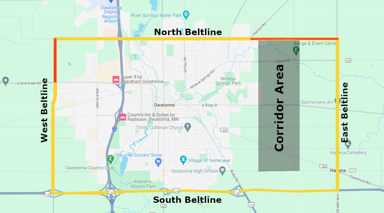
The beltline is meant to encircle the city, providing a quick travel route that bypasses most of the town, while a corridor is a road located between the city and the beltline, designed to handle more local traffic. In this case, the beltline will connect to Hwy 14, while a corridor will not.
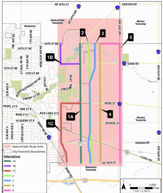
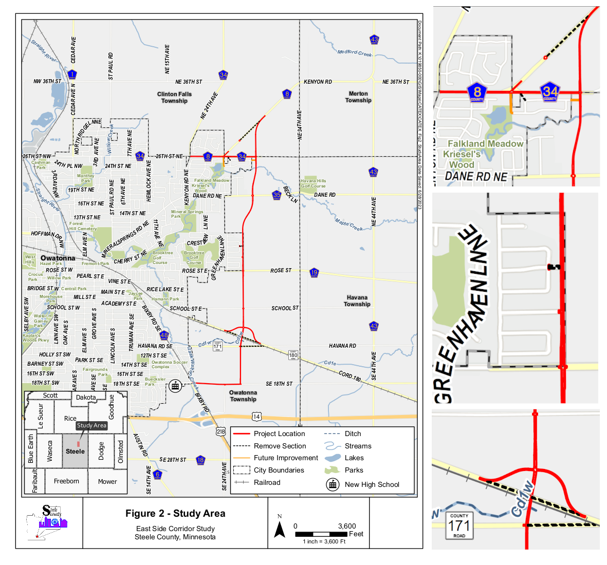
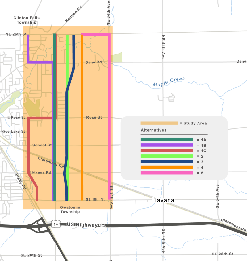
The beltline has been a project in progress for over three decades. Today, we have identified our beltlines, as shown by the rectangle around Owatonna. The red areas indicate where roads are currently missing. This current project focuses on a corridor that will connect 26th St to the north and 18th St to the south, situated closer to the city than the current beltline.
History
1990s to Early 2000s
Routes Identified: The routes were identified as 26th St. on the north, 29th Ave. on the east, Highway 14 on the south, and 24th Ave. on the west. The beltline was intended to connect to Highway 14, and right-of-ways were created as needed.
East Beltline: Studies were completed.
1993 - Alternatives were identified.
1995 - All alternatives were studied.
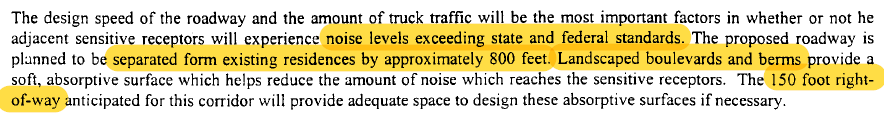
1999 - 29th Ave identified as the preferred alternative. (Noise level compliance: 150' right of way 800' spacing with landscaped boulevards and berms.)
2000 - Official Corridor map for the East Side Corridor was filed.
A corridor map is a suggested land-use map, representing an idea rather than a formalized route.
It does not create right-of-way or easement.
It does not appear on property deeds, nor does it appear in standard parcel searches without further investigation.
West Beltline: Approved for construction in the early 2000s but remains just shy of connecting to 26th St.
North Beltline: It was never extended or connected to the east, leaving a gap in the regional transportation network and undermining assumptions that the East beltline is insufficent.
1999
2003 - 2004
Housing Boom: The need for housing and growth became a priority, leading to annexation and subdivisions on the east side of town.
Neither Steele County nor the City of Owatonna purchased right-of-way or easements, and annexations were approved without contention.
Preservation Agreement: On March 9, 2004, the county and city signed a joint powers agreement to preserve the 29th Ave corridor map, giving both parties the first right to purchase or refuse and providing a six-month contention window.
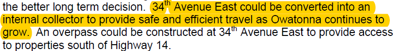
Recommendations: August 31, 2004, it was recommended that 44th Ave be used as the east side beltline with a connection to Highway 14. 34th Ave. was to be preserved for an inner corridor, and 29th Ave. was the city’s responsibility. Note: Study shows 34th Ave is a 66-foot owned right-of-way.
34th Ave Mapped: On Febrary 8, 2005, 5 months after the recommendation to preserve 34th Ave, an officially mapped right-of-way was created.
Post-2004
City Approvals: The city approved and permitted homes within the North Country subdivision to be built on 50 feet of the 29th St. right-of-way map from 2004 through today, platted other subdivisions on top of the right-of-way, and removed it from transportation plans.
No action was taken to carry the corridor map forward to newly assigned parcel IDs.
Outlots were classified as "Vacant Residential Land".
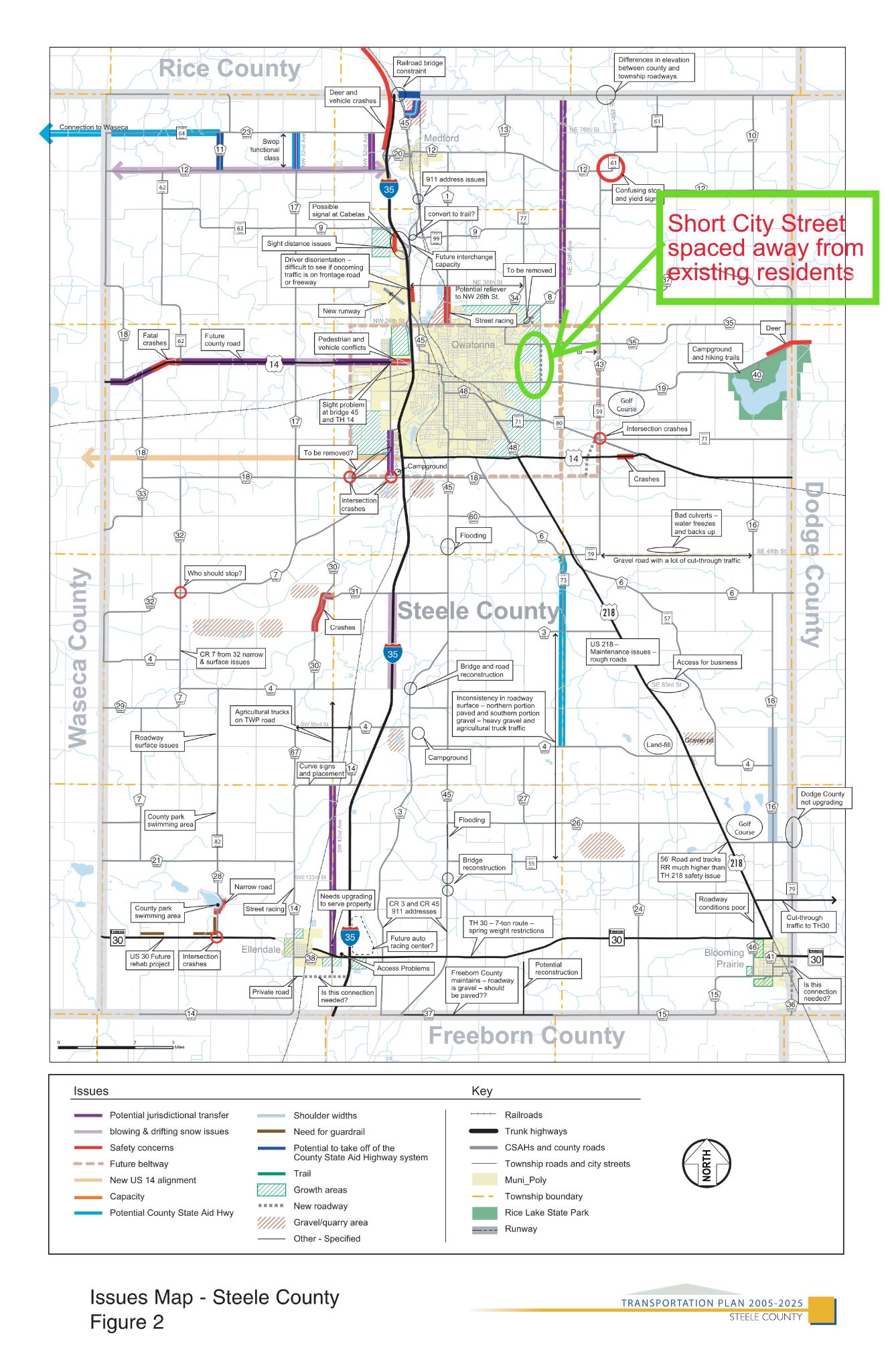
The 2005-2025 Steele County Transportation Plan, outlines plans for the construction of 34th Ave and 44th Ave, while indicating the mapped 29th Ave is no longer part of the plan.
2011
44th Ave: After many studies, 44th Ave was identified as a beltline to be connected to Highway 14 with an interchange. This was approved, and in 2021 44th Ave was connected to Highway 14 with an at-grade intersection.
Incomplete Beltline: 44th Ave. remains not fully connected, leaving two missing sections in our beltline.
2013
East Beltline MSA Designation Revoked: On August 5, 2013, the City of Owatonna unanimously adopted Resolution 72-13, revoking the East Beltline as a Municipal State Aid (MSA) designated roadway. The action released previously reserved MSA mileage so those funds could be used elsewhere.
"The mileage being removed was reserved for a future East Beltline. However, the segment being removed is non-existing and is not something we feel will ever connect."
— City Engineer, August 5, 2013
2015
Foreclosure: In 2015, the properties—including the outlots at issue today—went through foreclosure and reverted to the bank. The City of Owatonna did not intervene to preserve the corridor.
Adjacent property owners were never made aware of foreclosure.
2018
City-Owned Land: In November 2018 the City of Owatonna acquired the outlots when the bank transferred them to the City, at no cost, as part of a transaction to purchase a separate parcel for a neighborhood park, in North Country.
Outlots were never designated as right-of-way or easment.
The mapped corridor does not appear on the deed.
Corridor Development
2020
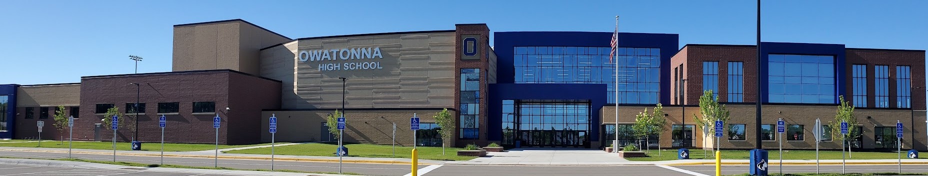
Need for Corridor: The City and County cited a need for a new corridor closer to Owatonna to accommodate traffic between the northeast side of town, the new high school, and Federated Insurance, as well as to reduce pressure on downtown routes. They claimed that some roads—such as Mineral Springs Road—were approaching capacity; however, available traffic studies do not support these claims. While 44th Avenue was expected to help traffic bipass Owatonna, it remains incomplete, so it’s unclear whether it would provide meaningful relief.
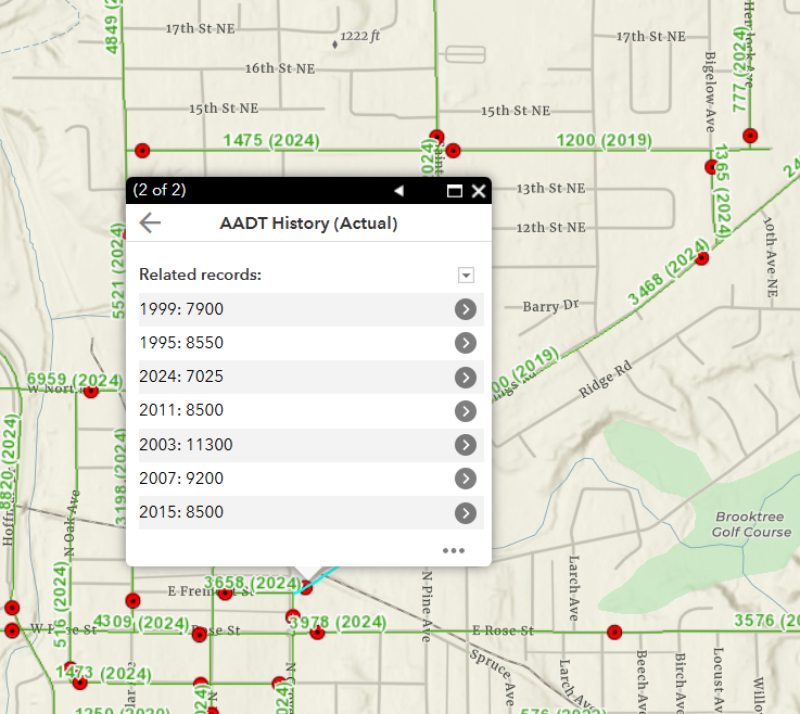
Traffic counts have decreased by 17.4% in the last 9 years and 37.8% in the last 20 years.
Source: https://www.dot.state.mn.us/traffic/data/tma.html
Traffic counts have decreased by 15.9% in the last 5 years and 19.3% in the last 20 years.
Source: https://www.dot.state.mn.us/traffic/data/tma.html
Recent Developments
2022
Project Publicized: The project was announced to the public two days before the first open house, where seven alternatives were presented.
Discussions and Feedback: Over the following year, residents were informed that no mitigation measures were planned and were asked to identify the safety measures they wanted. Any resident suggested mitigations were rejected.
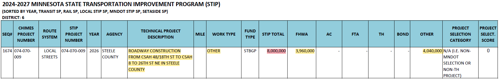
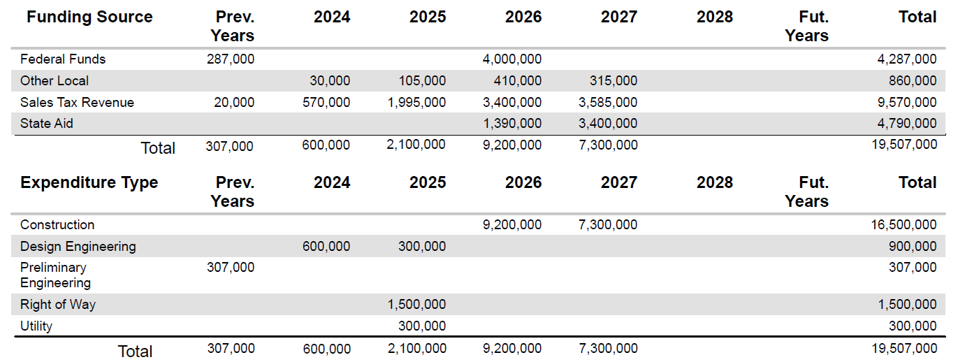
Initial Discrepancies: The project was submitted to the state as an $8 million endeavor with $3.96 million in FHWA funding, yet plans indicated it is a $20 million project. As of now, this remains unchanged.
May 2023 - Nov 2023
Second Open House: Visitors were informed that all options were still being explored.
Website Updates: Shortly after the open house, the alternatives map was quietly replaced by a map showing a single route over residents' houses and properties. This was how residents discovered that the county had proceeded with final environmental studies solely on 29th Ave., using outdated studies for justification.
Data Requests: Residents asked for data multiple times, but none was produced.
Narrative Shift: The narrative then changed to describe the project as a corridor, not a beltline. Officials claimed: a new project with a new purpose, invalidating data from previous studies.
Resident Concerns: Despite continuous inquiries, residents were informed that discussions couldn't take place until the environmental reports were completed. Meanwhile, the design process continued to advance. Updated maps with new connections and detailed designs were published on the website, yet conversations were still not permitted.
Revised Plan: The new plan map shifted the northern most section hundreds of feet from empty residential lots to the middle of a farmer's field while leaving the section by North County on top of homes. Inconsistent explanations were given for this change, ranging from environmental report information to floodplain concerns. Despite this, conversations couldn't take place because the reports were not yet back, and the section was not moved out of the floodplain. Why are we avoiding empty lots, but not existing residents?
7 alternatives quietly removed.
Northern section shifted hundreds of feet from empty residential lots, creating more farmland divisions and massive floodplain impacts.
The map was adjusted 25 feet east from the original mapped right-of-way misrepresenting the proximity to homes, yet it remains on top of houses and properties. Meanwhile, the northern section, just south of 26th St, was moved hundreds of feet to avoid empty residential lots.
Detailed designs were released before environmental reports were available.
November 2023
Encroachment: The County Engineer, Greg Ilkka, first learned from public comments, at a county commissioner meeting, that the mapped right-of-way encroached on residents' properties, despite residents raising this issue for nearly 1.5 years.
Noise Regulations: When residents proactively raised concerns about noise regulations for this type of project, elected officials repeatedly discounted their concerns and shut down conversations.
Narrative Shift: The narrative changed again, now the city administrator and assistant county engineer, Paul Sponholz, are advocating for both 29th Ave. and 34th Ave. without any supporting data or traffic studies.
Inconsistent Data: Residents discovered that traffic numbers provided by the assistant county engineer Sponholz, including daily and truck traffic, were not based on actual data or substantial findings and did not align with previous studies.
Metrics & Measures: When residents asked about project goals and how success would be measured, the engineer's response was "I don't know" and "we will just know" indicating a lack of concrete metrics.
Alternatives Being Studied: The number of alternatives being studied changed frequently, with 29th Ave. being predetermined without thorough examination of other options.
Conversation Requests: Residents repeatedly reached out, asking for conversations with elected officials. Emails went unanswered, in-person requests were met with the response that discussions couldn't occur until reports were back, and invitations were declined. By November 2023, only one commissioner and one city council member were willing to discuss our concerns.
Federal Scrutiny: Due to the lack of data, inconsistent answers, and lack of responsiveness, residents reached out to higher levels of government, prompting federal scrutiny and a restart of the project.
Federal Government Intervention
End of 2023
Funding Efforts: All city council members and Steele County Commissioners voted to seek additional funding for the trail alongside the ESC. While the commissioners and the chamber of commerce specified the ESC from 29th Ave, the city's letter listed the project as 29th Ave, raising residents' concerns that this misalignment could hinder funding if this is not the correct location. To date, no additional funding has been obtained, as confirmed by the state.
Project Restart: The federal government required a restart, noting that they wanted more scrutiny on this project. A restart will require all alternatives will be objectively studied with defined criteria and data, and additional Federal government signatures along the way.
Project Reset
May 2024
Milestone Reached: We now have a clear reason for an ESC and objective, measurable criteria to evaluate all alternatives. All options are back on the table and will consider various impacts, including some concerns that have been raised over the past two years. A new project with a new purpose requires updated studies that reflect the current landscape. This approach is similar to the 1995 study, which provided data for a wide range of criteria to determine the best location to further study before design and construction of the ESC. Previously, these studies favored 29th Ave because it offered the necessary protection from dangerous noise pollution by avoiding noise-sensitive areas like neighborhoods. However, since then, Owatonna has expanded until it occupied the same space as the mapped right of way.
Purpose and Need: This defines the project and why it is needed.
Evaluation Criteria: Provides the requirements each alternative will be studied against to determine a preferred alternative to study further before building.
County Announcement: The county mailed out a flyer on May 26, 2024, announcing the project restart and new milestones reached.
Commissioners Promises: Commissioners Abbe and Krueger vowed to make resident's safety the top priority in choosing a preferred alternative.
Memorandum
September 2024
Preferred Alternative Selection: The memorandum, created by WSB, the Steele County consultant, outlines key findings and recommendations regarding the East Side Corridor (ESC) project. However, it contained skewed or biased data, influencing the outcome in favor of certain conclusions or alternatives rather than offering an objective and balanced assessment of all options. This memorandum has prevented us from fully understanding the true costs of alternatives, namely Alternative 4, that meet the criteria based on WSB's own data. Instead of providing a clear, unbiased evaluation, it has further limited transparency and hindered informed decision-making.
Federal Memorandum - engaging with the document displays further comments.
Residents were denied the opportunity to participate in a formal public comment period. Despite state and federal recommendations—and the release of new information, including a $2.3M noise wall—the county refused to hold an open house, public hearing, or even a 30-day comment period.
Challenging Misleading Data: Prioritizing Safety, Accuracy, and Accountability in the East Side Corridor Federal Memorandum — An independent resident-led analysis of the East Side Corridor Memorandum revealed multiple red flags, including skewed data, omitted historical context, and the absence of standard travel time formulas. These issues suggest the document was written to support a predetermined outcome rather than provide an objective evaluation.
These findings raise serious concerns about transparency and the integrity of the decision-making process.
Key Findings:
Alternative 4, which had been largely dismissed despite offering the same benefits as Alternatives 2 and 3, was actually the cheapest and fastest option when industry-standard formulas were applied to calculate travel time and project costs. However, it would have required two separate roads, spaced hundreds of feet apart, leading to impacts on twice as much farmland.
Alternative 5 (34th Avenue) was only about $300,000 more expensive than Alternative 4. As a single-road solution, it resulted in significantly fewer impacts to farmland and existing land uses.
Read the full analysis to see how the data was manipulated and what a truly safety- and community-focused alternative could look like.
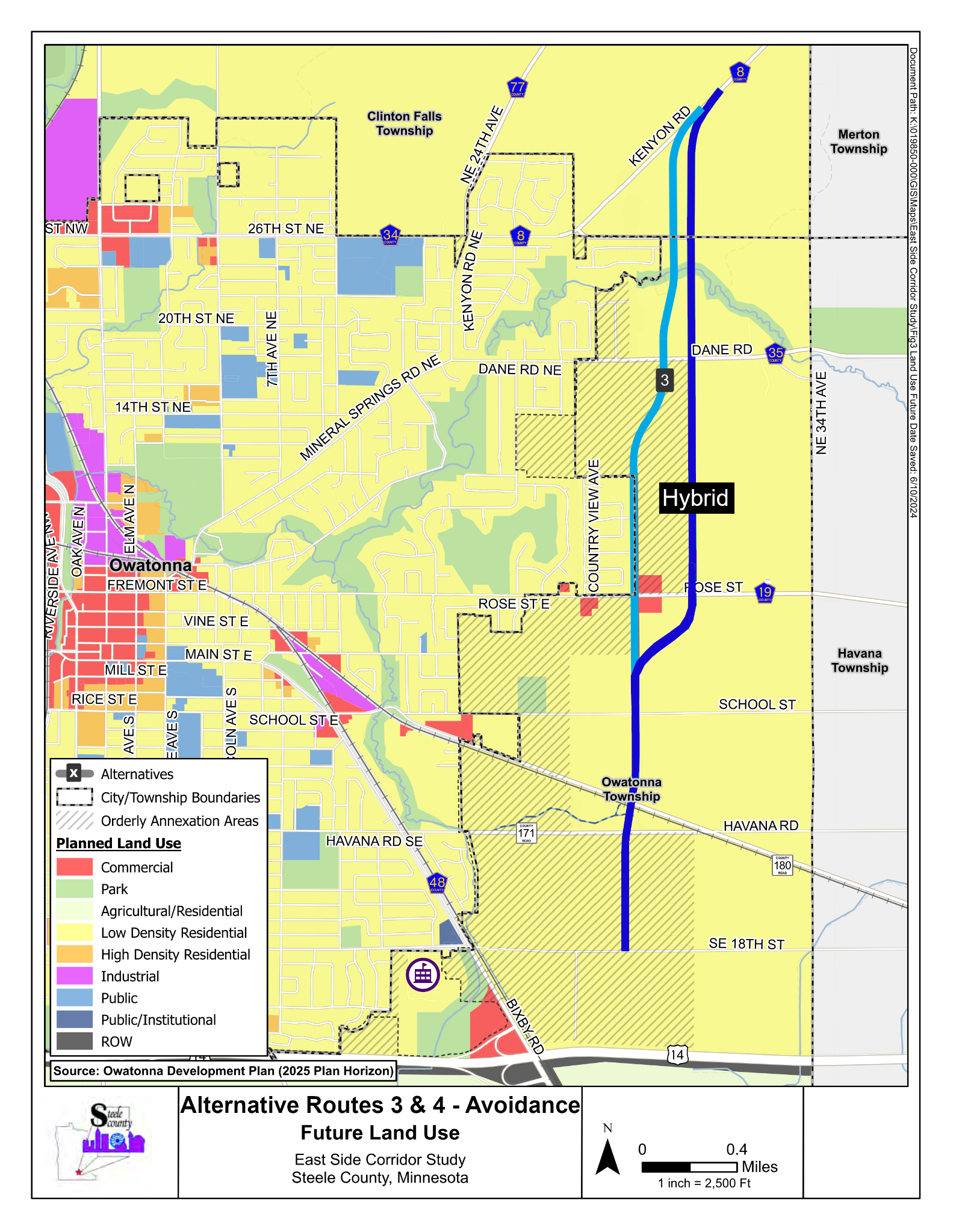
Hybrid Compromise
Decmber 2024
This proposed Hybrid Alternative combines Alternative 4 on the north half and 29th Ave (Alternative 3) on the south half, with a curve south of Rose Street to avoid residential impacts. Presented to the city and county in December 2024, it balances safety, long-term growth, and cost savings by eliminating the need for a $2.3M noise wall and maintaining a rural design instead of the costly $7.8M urban alternative. While the memorandum biasedly favored Alternatives 3 or 29th Ave, data supports that Alternative 4 meets the project’s purposes and needs, while Alternative 5 (34th Ave) did not. This hybrid is a compromise that addresses both resident and taxpayer needs, minimizing impacts and prioritizing safety and fiscal responsibility.
The Struggle for Open Government
October 2024
Residents Submit First Data Request:
Residents submitted their first data request to Steele County. However, they were denied access, faced delays, and were provided with inaccessible data. Despite Minnesota’s Government Data Practices Act, residents were also denied the use of their own equipment to capture public data.First Round of Public Data Received:
The first round of public data was provided to residents on December 27, 2024. Despite this, access was denied multiple times in January 2025.Second Round of Public Data:
After addressing public data concerns during public comment on February 11, 2025, residents finally received the second round of data, following delays, excuses, and promises of weeks of waiting.It has taken residents 15 hours to read all the data currently available.
January 2025
Residents Submit First Data Request to City:
In January, residents submitted their first data request to the City of Owatonna, only to face a similar lack of response and access as they did with the county.Residents Submit Petition to the County:
Residents submitted a petition with 578 signatures to the County for agenda inclusion, following the proper submission process. However, the County denied inclusion of the petition. When residents showed up to voice their concerns, they were locked out of the meeting.
(Final counts: 704 signatures)
February 4, 2025
County Officials Cut Off Communication:
The Steele County Attorney and Steele County Administrator cut off residents from all other county officials.
February 11, 2025
County Engineer Comments on Noise Wall Vote:
Following a commissioner meeting, County Engineer Paul Sponholz informed residents that a noise wall vote would happen within the next few weeks, followed by the Environmental Assessment Worksheet (EAW) comment period.
February 25, 2025
County Engineer Publicly Comments on Noise Wall Vote:
After residents who were locked out were allowed into the meeting, County Engineer Paul Sponholz publicly stated that the noise wall vote would occur within the next month or two and that it was the last piece needed for the EAW comment period, which was anticipated to take place in April or May.
March 25, 2025
Residents Launch GoFundMe Campaign:
To fund the filing of formal complaints with the state regarding ongoing data practice violations, residents launched a GoFundMe campaign.
March 27, 2025 - GoFundMe funded
GoFundMe Fully Funded:
The GoFundMe campaign reached its goal in under two days and was closed.
Additional Data Requests have been submitted by residents.
Unfortunately, nearly all of these requests remain unfulfilled.
Federal Funds removed
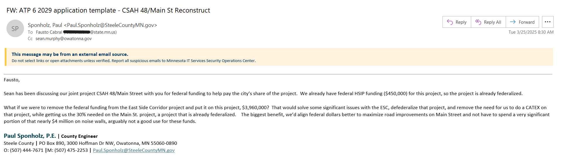
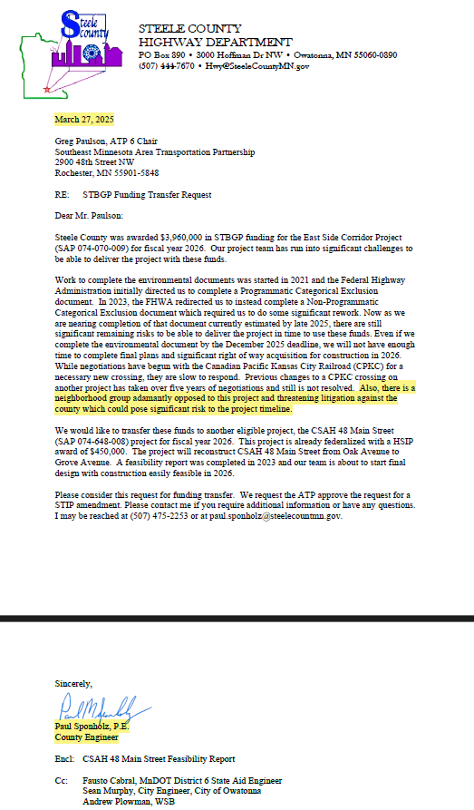
March 25, 2025
Federal Funds Removed:
The Steele County Engineer, requested to remove federal funds from the ESC project, thereby dropping federal regulations and safeguards from the project. This was done to avoid constructing a noise wall. The day after, the residents' lauched a GoFundMe campaign enabling them to move forward with filing data practice violation complaints with the state.
March 27, 2025
Formal Letter to SE MN APT Committee:
The County Engineer submitted a formal letter to the Southeast Minnesota Area Transportation Planning (APT) Committee to transfer the federal funds off the ESC project, bypassing the County Commissioners and acting 12 days before they had the oppertunity to discuss, and on the same day residents' GoFundMe was fully funded.
April 1, 2025
Residents Learn of Federal Funds Transfer:
Residents first learned of the transfer of funds from the ESC project during a city council meeting, where the ESC was conspicuously left off the agenda.MnDOT Cultural Resources Unit (CRU):
Determined that the East Side Corridor constitutes a federal undertaking due to scope creep, project impacts, funding involvement, effects on historic properties, and the need for federal permits.
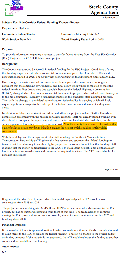
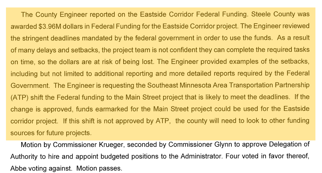
April 8, 2025
County Commissioner Meeting Agenda:
The transfer of federal funds was finally included on the county commissioner meeting agenda. Despite the reports being completed, the county raised concerns about meeting deadlines, citing "neighborhood litigation" as one reason for missing deadlines. However, residents have never indicated they intended to pursue legal action. This was further corroborated by the County Administrator in a 25-minute hostile interaction with residents, who were trying to calmly speak to their commissioner following the meeting.No Vote on $3.96M of Federal Funds:
Despite discussions, no vote was taken on the appropriation of $3.96M in federal funds, leaving no official record of the decision.False Claims of Litigation:
Due to false claims of litigation, all communication from commissioners to residents was cut off.Residents locked out of this meeting as well - a third time this year.
April 8, 2025 Steele County Agenda
April 8, 2025 Meeting Minutes - no vote on the appropriation of this money.
April 23, 2025
FHWA and MnDOT Warnings:
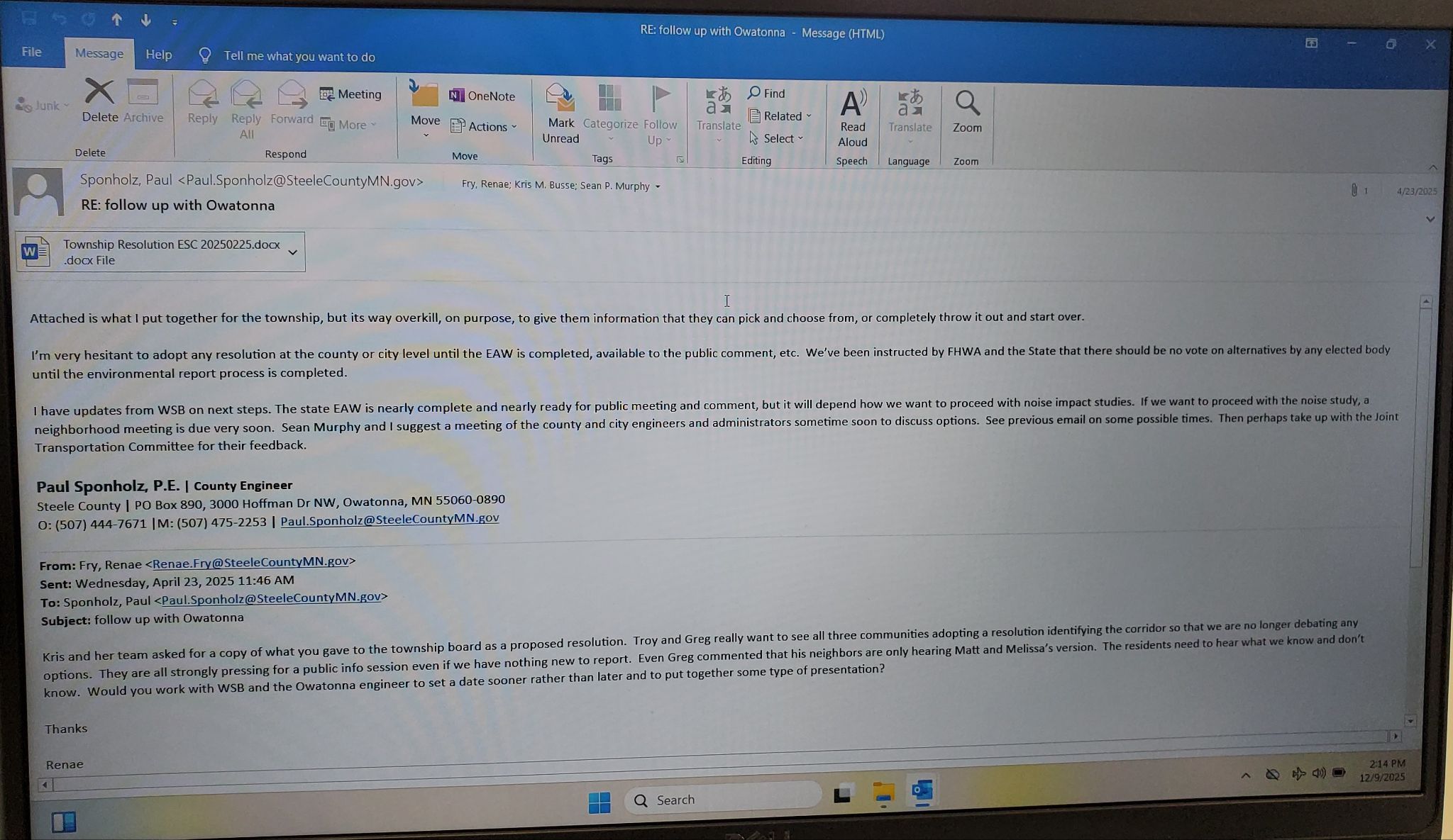
County Administration communicated that certain city staff wanted formal resolutions from all three local government entities identifying a corridor location so that debate over alternatives would end. In response, the County Engineer emailed the County Administrator, City Administrator, and City Engineer stating that Steele County had been explicitly instructed by FHWA and the State that no elected body should vote on project alternatives until the environmental review process was complete.Noise Study and Neighborhood Impacts:
In the same correspondence, the County Engineer advised that next steps depended on how the County chose to proceed with the noise study and stated that a neighborhood meeting would be due very soon to discuss noise impacts and options. This recommendation reflected the presence of substantial potential noise impacts. The referenced neighborhood meeting never occurred, and instead of addressing the known impacts, the County later asserted a noise exemption.Joint Transportation Committee Meeting:
The County Engineer further recommended bringing the issue before the Joint Transportation Committee to gather feedback from elected officials on how to proceed. The public is not permitted to attend Joint Transportation Committee meetings, and records and data related to these discussions have been withheld from public data requests submitted to both the City and the County.
County Engineer, Paul Sponholz Resigns
May 7, 2025
Steele County Engineer Accepts New Position:
The teele County Engineer accepted a new position as the Cottage Grove City Engineer. Residents made this information known after watching the Cottage Grove City Council meeting. Steele County did not announce this until after the May 13th County Commissioner Meeting.
May 13, 2025
County Commissioners hand over nearly $2 MILLION dollars to the Engineer on his way out the door. Watch here.
Nearly $1M of that went to WSB:
The county approved contacts on the ESC project to map right of way, mitigation designs, and other final designs - work that cannot begin until the environmental studies are complete, yet the engineer told the board these things were needed to complete the environmental documents. See the new contract here.
On April 8, 2025, the County Engineer told the board that after five years, the county was back at square one on the 18th Street roundabout due to a failure to reach an agreement with the railroad—largely because the county had knowingly started the project without the proper permits, placing it too close to the tracks. Despite this, the county suddenly approved hundreds of thousands of dollars to move the project forward, even though it has not yet been accepted into a federal program, to prevent Steele County from assuming 100% liability. The abrupt shift raises serious questions about oversight, accountability, and the urgency behind the decision.
The 18th St Roundabout had been coupled to the ESC prior to the ESC being publicly announced.
There was no public input allowed.
The Havana project (WHKS)
The prior meeting commissioners hesitantly selected an alternative, while pushing the project back by a year to collect data to see if the newly installed 4 way stop solved the problems.
The decision to finalize designs was also moved forward without environmental studies completed and presented to the public.
The engineer noted that bridge costs were included alternative 4b. The bridge project is a stand alone project with separate funding. Were costs double counted inflating the cost of an alternative to also serve a predetermined outcome?
Nearly $600K for a resurfacing project.
May 27, 2025
Steele county Approves $6MILLION more in engineering projects, days before the engineer walks out the door. Watch here.
$4.6M to WHKS to CR 180 Bridge under Canadian Pacific Railroad Bridge Study and Analysis
Almost $600K for CSAH 28 Reclamation project
$267K for pavement remarking
$500K to WHKS for professional services on the Beaver Lake project – a project which the engineer again indicated he intended to bring eminent domain before leaving.
Township Resolution
A resolution included in the Steele County Board meeting agenda stated that Owatonna Township only supports an East Side Corridor (ESC) alignment built just 17 feet from residents’ homes. However, the resolution raises serious procedural and legal concerns:The resolution was dated May 13, 2025, but Owatonna Township’s regular board meetings occur on the second Wednesday of the month—which, in this case, was May 14, 2025.
It was listed as coming from the Public Works Committee, which met at 8:00 AM on May 13, yet the resolution was not included on that meeting’s agenda or in the official minutes.
This raises a critical question: How was a resolution signed and included in the ESC agenda before either the Public Works Committee or Township Board officially met—and with no public record of its approval?
No resolution or action may lawfully be taken to limit alternatives before environmental studies are complete, as required under state and federal law (MEPA/NEPA). Advancing a resolution that dictates a 17-foot alignment appears to prejudge the outcome of that process.
This occurred just weeks after the April 8 incident, when Commissioner Abbe appeared to learn for the first time that the Township was being given decisive influence—following the same meeting where County Administrator Fry initiated a hostile 25-minute exchange with residents for trying to speak to their commissioner.
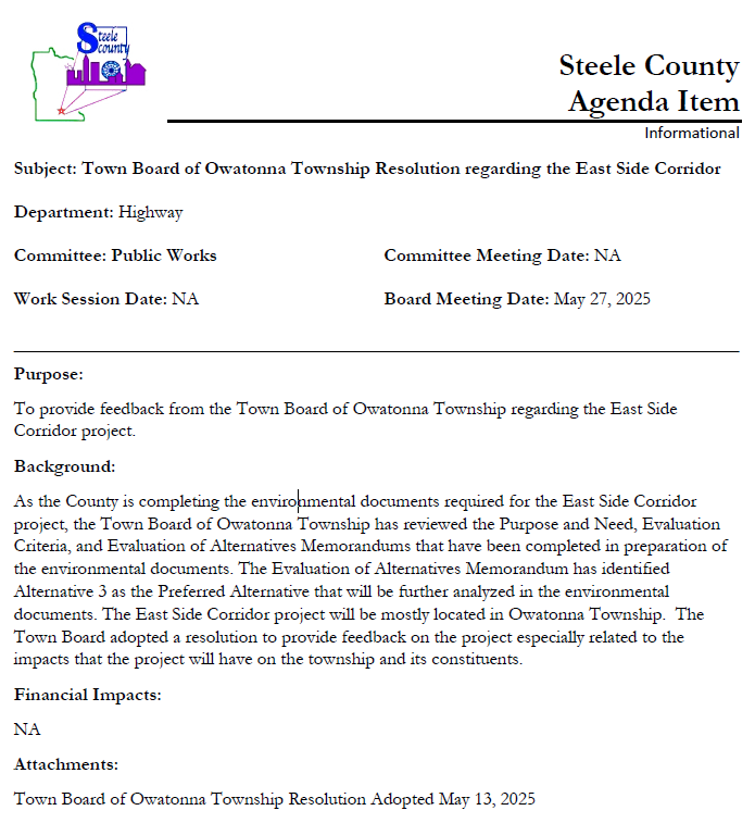
Township Resolution Presented by the Public Works Committee Despite No Record of Approval
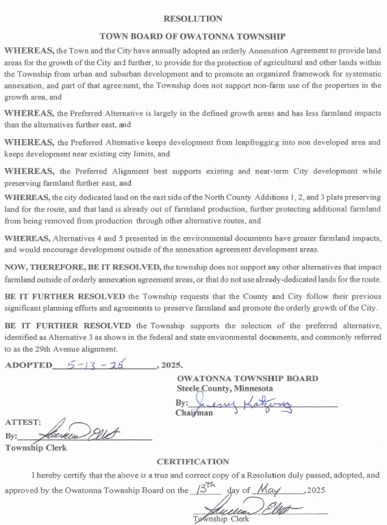
Township Resolution Signed on May 13, 2025—One Day Before the Township’s Scheduled Meeting on May 14, 2025
Residents Take Formal Action
May 2025
Residents Submit Formal Data Complaint:
After ongoing issues with delayed, inaccessible, and unfulfilled data requests, residents submitted a formal data complaint to the Department of Administration. The complaint, detailing violations of the Minnesota Government Data Practices Act, was accepted for review.Verbal Complaint Filed with Steele County:
During the open comment period at the May 27, 2025 Board meeting, residents expressed concern that their emails were being accessed without authorization and not kept confidential. In response, they submitted a verbal complaint to the county citing defamation, retaliation, intimidation, dissemination of misinformation, and violations of the Minnesota Government Data Practices Act. The complaint followed public accusations by the county that residents were threatening litigation—an allegation prompted solely by their launch of a GoFundMe campaign to support a public data complaint filed through lawful and protected procedural channels with the state.
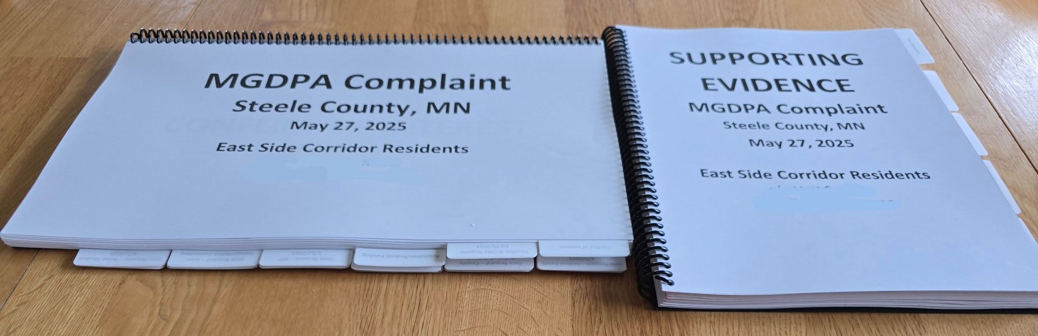
Public Data Violations and Supporting Evidence Submitted to the Minnesota Department of Administration
KAAL News Coverage and Follow-Up:
KAAL reached out to residents to report on the East Side Corridor (ESC). During their visit, residents shared key safety concerns. The next day, the reporter returned to meet with city and county officials and asked for the justification behind the ESC. The official response: to reduce downtown congestion and truck traffic on Crestview Lane and Shady Avenue. However, WSB’s own reports show the ESC would reduce congestion on Mineral Springs Road by only 2 seconds, with no improvement at other congested intersections. In fact, 18th Street and Oak Avenue would see worse traffic impacts. (Federal Memorandum)Data Request Exposes Lack of Truck Traffic Evidence:
Residents submitted a public data request to determine how much truck traffic actually exists on Crestview and Shady. The response? No studies, no traffic counts, and no documentation—only vague recollections from phone calls. The entire justification appears to rest on 2 seconds of relief and zero supporting data.
May 22, 2025 - Residents address safety concerns
May 23, 2025 - To releave truck traffic and save 2 seconds
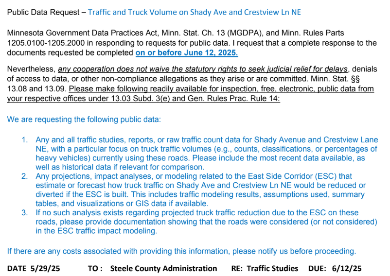
May 29, 2025 Data Request
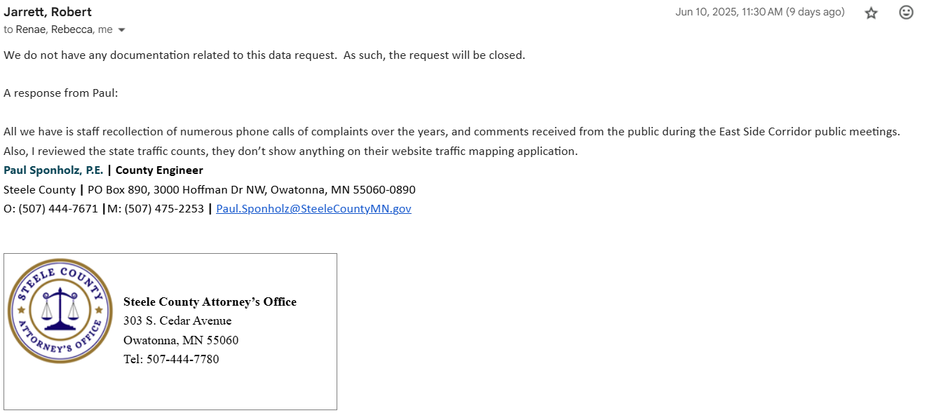
Steele County’s Response to Data Request Acknowledging No Traffic Studies—Only Vague Recollections
June 2025
Written Complaint Submitted to Steele County:
A formal written complaint was submitted to Steele County and copied to the Minnesota State Auditor. The complaint addressed the same core issues raised verbally: defamation, retaliation, intimidation, misinformation, lack of compliance with public data laws, and suppression of resident voices. The complaint also reiterated public demands for:A pause on all engineering projects until investigations are complete
Independent investigations into legal, ethical, and financial misconduct
Full access to inspect public data, in accordance with MGDPA
Compliance with MEPA and NEPA environmental review laws
Restoration of public trust through transparency and accountability
June 10, 2025
Residents locked out of the fourth meeting this year!
Formal Complaint Submitted to Each Steele County Commissioner
October 2025
MNGDPA Hearing
Residents’ Minnesota Government Data Practices Act (MGDPA) complaint was advanced to a formal hearing. At the County’s request, the hearing was split over two days to accommodate the County Engineer’s schedule: October 10 and October 17, 2025.After requesting two full days for the hearing, the County did not include the County Attorney on its witness list. Preliminary matters were addressed on October 10, and the hearing was stayed until October 17, 2025, when the full evidentiary hearing took place.
Residents represented themselves, pro se.
Following the hearing, post-hearing briefs were due November 7, 2025, with a ruling to follow 10 business days later on November 24, 2025.
On October 28, 2025, the Public Works Director was appointed as County Engineer, added to the County Board agenda at the last minute on October 27, 2025.
November 18, 2025
While the data practices case was still pending—and while residents were continuing to be denied access to public data—Steele County opened the Environmental Assessment Worksheet (EAW) comment period.
November 24, 2025
MGDPA Ruling — Residents Substantially Prevailed
The Administrative Law Judge ruled that Owatonna East Side Corridor residents substantially prevailed.The ruling found that Steele County violated two Data Practices statutes on multiple occasions. The Judge ordered the maximum penalties, including:
Maximum civil penalty
Compliance with the Minnesota Government Data Practices Act
Payment of court costs for the hearing
December 11, 2025
ESC Open House
Hundreds of residents attended
Public comments submitted
December 16, 2025
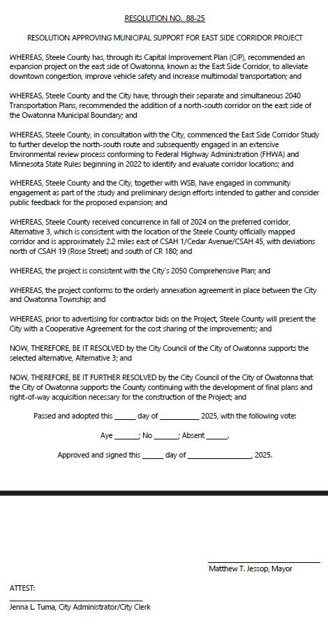
City of Owatonna Passes Resolution:
Limiting Alternatives
Approving Right-of-way Acquisition
Agreeing to Cost Sharing
After Recieving Notice from Residents Raising Concerns
Watch City Council pass the resolution starting at 37:50 and residents' comments at 1:16:50-1:22:35
December 31, 2025
EAW Comment Period Closed
Residents were not provided access to meaningful project data during the comment period
More than 1,800 of approximately 2,200 emails previously produced in public data responses were later deleted or otherwise unavailable
More than 200 comments were submitted to the EAW, totalling 1500 pages
Where are we now?
See the Legal Record & Accountability Timeline to understand where things stand now.
Date: TBD
New County Engineer Appointment
Steele County will be hiring a new County Engineer. Residents are hopeful that new leadership will take the time to review all current projects, engage with stakeholders, and ensure proper oversight, transparency, and accountability moving forward.
What Didn't Happen?
Avoidance was not meaningfully evaluated or prioritized
Impacts to existing residents were not adequately analyzed or prioritized
Transparency was not consistently provided throughout the review
Future development and cost sequencing were not evaluated
Residents' safety was not prioritized over development desires
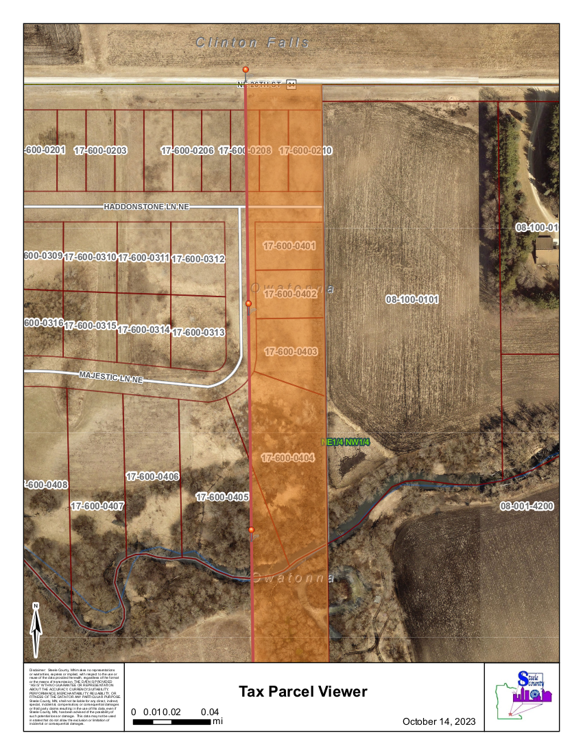
29th Ave.
Not Preserved: The right-of-way was not preserved, and should it be built adjacent to existing subdivisions, mitigation efforts are limited to noise walls, which are costly.
Regulatory Concerns: Previous studies platted a road of this type 1200 feet from subdivisions to comply with noise regulations.
Farmland Impacts: This route would divide several farms and remove 64 acres of prime farmland.
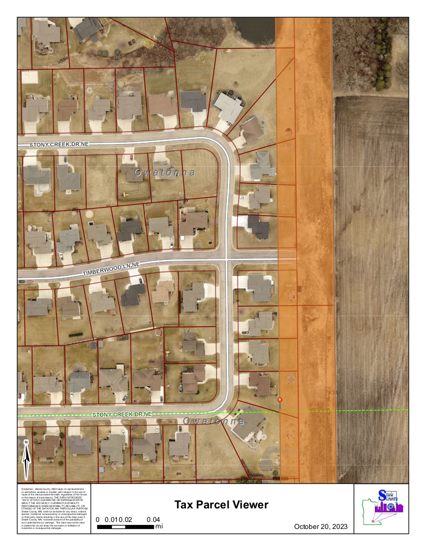
Wetlands: Previous studies indicated that 29th Ave has the most wetlands, including several ponds around the North Country subdivision designed to prevent flooding.
Floodplains: This route crosses the largest floodplain area along the corridor, which has a documented history of flooding nearby neighborhoods when land was disturbed for development.
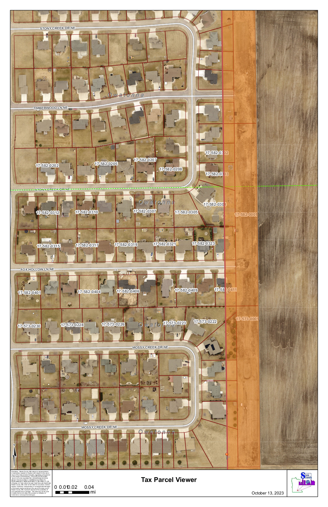
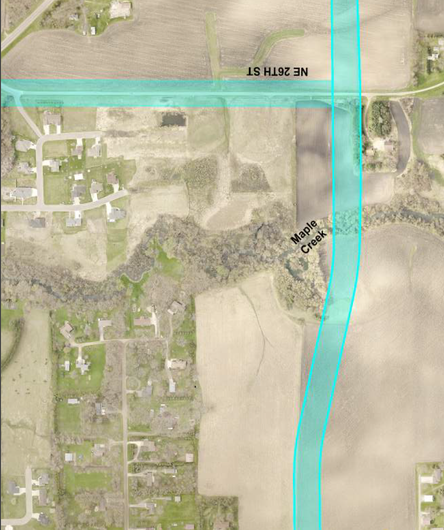
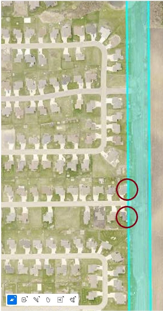
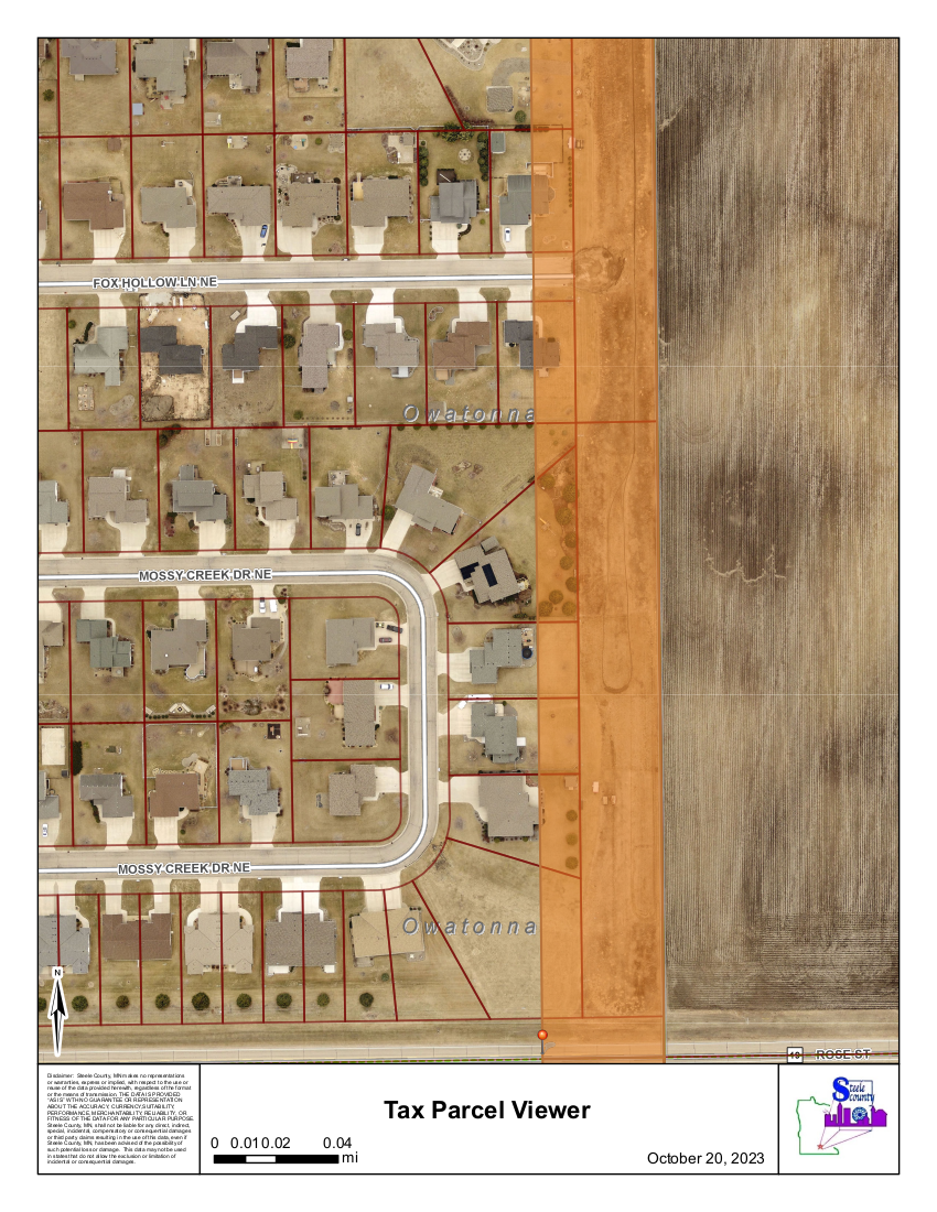
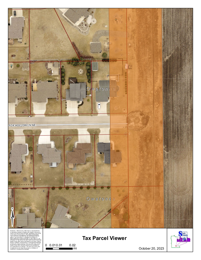
Noise: This alignment would be located as close as 17 feet from existing homes, resulting in substantial noise impacts.
County noise modeling shows noise increases of up to 25 dBA for many homes that currently experience baseline levels around 20 dBA. Under established noise standards, an increase of 5 dBA is considered a substantial change; increases of this magnitude represent a dramatic alteration of living conditions.
The County’s own noise analysis—withheld during the EAW process—identified a 20-foot noise wall as feasible, reasonable, and recommended, yet this mitigation was not disclosed or evaluated in the EAW.
Based on available data:
371 homes would experience increased roadway noise
82 homes would be substantially impacted
57 of those homes are located in the North Country Subdivision
34th Ave - The Answer for More than 150 Years; Prematurely Eliminated from Studies
Proposed Route: 34th Ave. is 0.55 miles from the proposed 29th Ave. route on 26th St. It follows parcel lines and was recommended for this use in previous studies.
Safety and Growth: Building 34th Ave. makes sense for safety and planned growth, providing an opportunity for small businesses that could act as a noise buffer for future developments. Although such developments are not expected immediately, they offer future plans and opportunities.
Existing Road: 34th Ave was once a functioning road that was later tilled under. Today, portions of a minimum maintenance road follow parcel lines, reducing the number of bisections.
Wetlands: Previous studies showed that 34th Ave has significantly fewer wetland impacts than any other route.
Floodplain: Crosses Maple Creek where it has previously been disturbed by a roadway, as reccomended by the Historical Society in the 90s. The flood plain crossing is much narrower here reducing construction mitigation costs, and once had a historical bridge crossing it (removed in 2005).
34th Avenue is the most logical choice for the East Side Corridor (ESC), offering a safer solution that aligns with long-term growth and Owatonna’s development plans. It meets noise regulations, protects residents, and as an existing road and owned right of way it prevents significant harm to prime farmland.
When current traffic data, accurate distances, and standard travel-time calculations are applied, the 34th Avenue alternative performs only a few seconds slower than Alternative 4 and faster than 29th Ave in most cases.
Despite this marginal difference, the 34th Avenue alternative performed competitively across evaluation criteria yet was removed from further consideration through selective and inconsistent application of screening criteria, while the 29th Avenue alignment was advanced as the preferred alternative.
This option prioritizes safety, minimizes impacts, and ensures responsible use of taxpayer dollars while prioritizing residents and future needs.
Hybrid Compromise - Resident Proposed; RGU Ignored (No longer an option)
Overview: The hybrid option combines Alternative 4 on the northern half and 29th Avenue on the southern half, incorporating a curve south of Rose Street to avoid residential impacts in the north.
Safety and Growth: According to the Federal Memorandum, Alternatives 2-4 provide the same benefits. The hybrid alternative stands out by prioritizing the needs of current residents while accommodating planned growth, ensuring long-term benefits for both present and future community members.
Fiscal Responsibility: This option could save $5–10+ million. It eliminates the need for a $2.3 million noise wall to protect residents and replaces the costly $7.8 million urban roadway design with a more economical rural roadway alternative.
Farmland Concerns: The hybrid route follows parcel lines, reducing the likelihood of bisecting farmland and minimizing disruption to agricultural operations.
Additional Benefits:
Maintains the planned railroad crossing and terminates closer to the city limits on the southern side.
Adheres to the safety distance proposed in the 1990s to protect existing residents from the detrimental effects of noise, light, and air pollution.
And so much more!
The hybrid was a resident proposed compromise that balances safety, fiscal responsibility, community well-being, and development while addressing growth and environmental considerations.
3B - Governement Studied; Publicly Withheld (No longer an option)
Overview: Similar to hybrid option-avoids North Country by 600-800 feet on the northern half with a curve south of Rose St to join 29th Avenue on the southern half. Starts and ends in the same points as 29th Ave.
Safety and Growth: We don't know, all data was withheld
Fiscal Responsibility: We don't know, all data was withheld
Farmland Concerns: We don't know, all data was withheld
Additional Benefits: We don't know, all data was withheld
Alternative 4 - Fastest and Cheapest Route; Never a Real Consideration
Overview: This alternative generally follows existing parcel lines but would still bisect significant areas of farmland.
Using current traffic data, accurate distances, and standard travel-time formulas, Alternative 4 showed the best overall travel-time performance, though the difference amounted to only seconds compared to the 34th Avenue alternative (Alternative 5).
WSB’s own analyses indicate that Alternatives 2–4 provide similar levels of traffic relief and similar usage, with only minor differences between them. Despite this, Alternative 4 was removed from further consideration early in the process.
From a fiscal perspective, Alternative 4 was the lowest-cost option, though its estimated cost was approximately $300,000 less than Alternative 5, a relatively small difference given the overall project scale.
While this alignment follows parcel boundaries, it would still result in greater farmland impacts and additional field bisections, as many agricultural operations span multiple parcels.
Located 0.25 miles from 34th Ave.
Despite performing the best, Alternative 4 was removed from further consideration through selectively and inconsistently applied screening criteria, while 29th Ave was advanced as the preferred alternative.
Conclusion
The East Side Corridor is a project of significant scale and consequence. Decisions of this magnitude—affecting neighborhoods, farmland, floodplains, safety, and tens of millions of taxpayer dollars—require a complete, accurate, and lawful environmental review.
To date, key elements of that review have not been prioritized, including avoidance, resident impacts, floodplain risks, noise mitigation, and long-term development planning. Alternatives with comparable or superior performance were removed early, while mitigation measures identified as feasible and reasonable were not disclosed or evaluated during public review.
This effort has never been about opposing infrastructure. It is about ensuring that public decisions are made transparently, based on sound data, and in compliance with environmental and public process laws. Until those standards are met, the process remains incomplete.
Residents remain committed to seeing this project evaluated responsibly and lawfully. If necessary, this includes pursuing additional environmental review—such as a full Environmental Impact Statement (EIS)—and other lawful oversight actions to ensure that any outcome reflects informed decision-making, protects communities and farmland, and ensures responsible use of taxpayer dollars.